|

Click here for a REAL map with the
physiographic regions and county lines. |
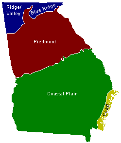
So, what's with the
colors? It depends on the source, but Georgia is usually
divided into as few as three and as many as six physiographic regions.
For the purposes of this web site, I have lumped the Southern Blue Ridge
Mountains (northeast Georgia), Ridge & Valley (northwest Georgia) and
Cumberland Plateau (extreme northwest Georgia) into a generic "Mountain"
Region; lumped the Upper and Lower Coastal Plains into a "Coastal Plain"
Region and split the immediate coast and barrier islands from the
Coastal Plain. The color preceding each county represents the
physiographic region in which each county is predomiately located.
The color key is as follows:
| |
Mountain
(Blue Ridge / Ridge & Valley / Cumberland Plateau) |
|
| |
|
Mountains /
Piedmont Transtion Counties |
|
|
|
| |
|
Piedmont /
Coastal Plain (Fall Line Counties) |
|
|
|
| |
|
Coastal
Plain / Coast & Barrier Islands |
|
|